Types of Active Remote Sensing Being Used Today
What is Active Remote Sensing?
Active remote sensing uses active sensors from a platform, which allows the sensors to direct energy at an object in the form of electromagnetic radiation (EMR). The object is scanned and the sensors detect any radiation reflected back from the object, which allows the system to gather specific information about the object. On the other hand, passive remote sensing uses the natural radiation emitted or reflected by an object to gather information.
The key to remote sensing is EMR. EMR is the primary medium of transfer of energy. The spectrum of EMR consists of radiation in different wavelengths, such as visible light, radio waves, microwaves, infrared and so on. In remote sensing, both passive and active, information about an object is gathered without any physical contact with the object. This is accomplished by detecting EMR coming from the object. Data can then be inferred based upon the information gathered and can be applied to achieve results.
Types
Based upon the range of the electromagnetic spectrum, there are three distinct types of active remote sensing:
1.
Active Optical Remote Sensing: Active optical remote sensing involves using a laser beam upon a remote target to illuminate it, analyzing the reflected or backscattered radiation in order to acquire certain properties about the target. Generally speaking, the velocity, location, temperature and material composition of a distant target can be ascertained using this method. An example of a highly sophisticated active instrument is the LIDAR (LIght Detection and Ranging). The instrument works by using a transmitter and a receiver. The laser generates pulses which excite the specified target, causing it to absorb radiation at certain wavelengths. The target then reflects radiation in the form of photons which are detected by the LIDAR’s sensors and converted to an electrical signal.
Applications of LIDAR have been numerous, ranging from archeology, geology, forestry and atmospheric physics to name a few. One example of the application of LIDAR in meteorology is for the study of aerosols and clouds. Another example is using LIDAR to determine how much carbon dioxide is in the atmosphere. In agriculture, it has been used to help farmers determine what regions of the field expensive fertilizers need to be applied to. In law enforcement, LIDAR is replacing radar guns for the measurement of vehicle speed, and LIDAR guns are proving their worth. The automobile industry has also started using it for Adaptive Cruise Control (ACC) systems.
LADAR (Laser Detection and Ranging) is the acronym that is used in military parlance for LIDAR. A limitation of this system has been the sensor range. Wider laser pulses are being employed to overcome the limited range of sensors, however, this limits the resolution of the target location. Coherent detectors using ultra-fast photodiodes for better handling of the optical signal are now being developed to improve the overall efficiency. Many are now commercially available.
- Active Thermal Remote Sensing: Thermal remote sensing deals with information acquired primarily in the thermal infrared range. The majority of the thermal remote sensing is done using passive sensors. LIDAR can be used as an active thermal remote sensing instrument to deploy laser beams in order to gather data. However, most of the active thermal remote sensing methods have not been well researched and need more time for development.
3.
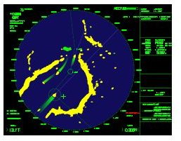
Active Microwave Remote Sensing: Active microwave remote sensing uses sensors that operate in the microwave region of the electromagnetic spectrum. Radar (Radio detection and ranging) is an example of active microwave remote sensing. The basic principle of radar is that the sensor transmits a microwave (radio) signal upon a specified target. The reflected or backscattered radiation from the target is then detected by the active sensors which measure the round trip time delay to targets allowing the system to calculate the distance of the target from the sensors. Important applications of radar include altimeters which are used on aircraft for altitude determination, Doppler weather radar for weather forecasts, radar is used extensively by government agencies for intelligence and surveillance, marine radars are used to determine the distance of ships to avoid collisions, radar systems are also used to monitor traffic of ships in busy waters.
These are just some of the applications of the different types of active remote sensing technologies. As technology improves with time we will see more.
Future of Active Remote Sensing

The National Aeronautics and Space Administration (NASA) is working on several projects to improve the efficiency of lasers used in active remote sensing instruments. One such project is a joint venture between NASA and the Canadian Space Agency known as ORACLE (Ozone Research with Advanced Cooperative LIDAR Experiments). ORACLE will use global remote sensing to provide data about the ozone. The ORACLE laser, an ultraviolet laser, will be the most efficient laser of its kind enhancing the capability of the instrument. Already NASA has used LIDAR for atmospheric measurements of the planet Mars. NASA plans on using active microwave remote sensing sensors in the future to measure precipitation, study ocean topography, measurement of the ozone, accurately measure river levels and for several other applications.
Advances in lasers will enable better instruments for active remote sensing which could be used to monitor oil spills. Using active hyperspectral sensors it may be possible to detect minute changes in wetland systems. Many other uses for active remote sensing are on the drawing boards, and we will see more and more of the technology being put to good use.
Credits
1. https://docs.google.com/viewer?a=v&q=cache:jZaJ7KQcay0J:www.jars1974.net/pdf/02_Chapter01.pdf+types+of+active+remote+sensing&hl=en&gl=ca&pid=bl&srcid=ADGEESiLbTG0Pl7eiuZR68JIoysF03WBMbbEEgV-rK1moZ-NMxJfWe-VKx1FrXxI7eaLChjwC_pHLndphX3aTHkAKfWw3OS3oD0sQDy1cddMRnSJMkGxbjq97IsJjXQnzG6ap77G1agT&sig=AHIEtbS-h6ztDpTqJ3XUoTgEB7rWcgwPuQ
2. https://docs.google.com/viewer?a=v&q=cache:4Riut8_UMWUJ:https://helda.helsinki.fi/bitstream/handle/10138/23901/Contributions85.pdf%3Fsequence%3D1+active+optical+remote+sensing&hl=en&gl=ca&pid=bl&srcid=ADGEESjKzPeU1L0QKbnxLdZioLrjxaecPyqFnTHMKGQyYdUz1L5FBsB38l7d9jmdZMVOCdOEMUYH8tc1YC1Vmft00IZKATw4WDXfYIPE_61Iw7QeaDtkkilfFb8s3yjHqblPFWvD9nlG&sig=AHIEtbTFKxXGhIYFf-zy7KwYQbTHu0c07w
3. https://www.aero.org/publications/crosslink/summer2004/04.html
4. https://www.agu.org/meetings/ja09/ja09-sessions/ja09_A33D.html
5. https://www.nasa.gov/centers/langley/news/factsheets/RemoteSensing.html
Image Credits: Wikimedia Commons/CIA/S.Winkvist/Mysid/NASA